Ate Visser (15-ERD-042)
Project Description
Stream flows represent a critical component of water security in areas such as California that rely on delayed delivery of alpine snow melt and discharge from catchment storage to supply water to households, agriculture, industry, and energy production. Prolonged drought can present a serious vulnerability to alpine water supplies when upstream catchments lack the ability to maintain stream flows. This vulnerability is dependent on strong dynamic interactions between precipitation, catchment storage, and water losses to evaporation and plant transpiration. Our goal is to provide an integrated sensor-modeling tool for accurate and reliable predictions of stream flow under extended periods of drought. Disparities in annual stream flow predictions between drought forecast models are up to 35%. This uncertainty has a direct impact on decisions to partition limited water resources between customers with distinct interests. Using a combination of unique isotopic tracers, high-performance computing, and highly instrumented catchments, we will constrain fluxes and sources of evaporation and plant transpiration, directly quantify the effective catchment storage, and assess which catchment parameters indicate stream flow vulnerability to drought. Enhanced predictions of drought impacts on stream flow will contribute to a global situational awareness for water security.
We will track water through the critical zone, the thin veneer of Earth that extends from the top of the vegetation to the base of weathered bedrock, by integrating multiple-isotope fingerprints into a coupled hydrology and land-surface model (ParFlow and Common Land Model) at the Southern Sierra Critical Zone Observatory in California's Sierra Nevada mountain range. We anticipate that continuous in situ measurements of water vapor isotopes will enable major progress in partitioning evaporation and plant transpiration, leading to a better implementation of evaporation and plant transpiration in land surface models. This work will address the ability of plants to access deeper and older sources of water stored in alpine catchments. Our research will be the first to apply cosmogenic isotopic tracers in an emerging field of hydrological sciences that revolutionizes stream flow predictions by incorporating water age. We will reveal which catchment parameters result in low effective storage volume and high evaporation and plant transpiration rates, indicating severe vulnerability to drought. Reduced uncertainty in drought impacts has a direct social and economic relevance. Our results will further enable accurate incorporation of groundwater in the coupling between the land surface and the atmosphere in climate models.
Mission Relevance
The electricity industry is second only to agriculture as the largest user of water in the United States, accounting for 39% of all freshwater withdrawals in the nation. The energy required to treat and deliver water accounts for as much as 80% of its cost. In California, 19% of total electricity demand is related to water. Our project to produce an accurate model for reliable predictions of stream flows is, therefore, highly relevant to the Laboratory's energy and climate strategic focus area. It also strengthens the core competency in nuclear, chemical, and isotopic science and technology relevant to elucidating environmental and climate changes.
FY16 Accomplishments and Results
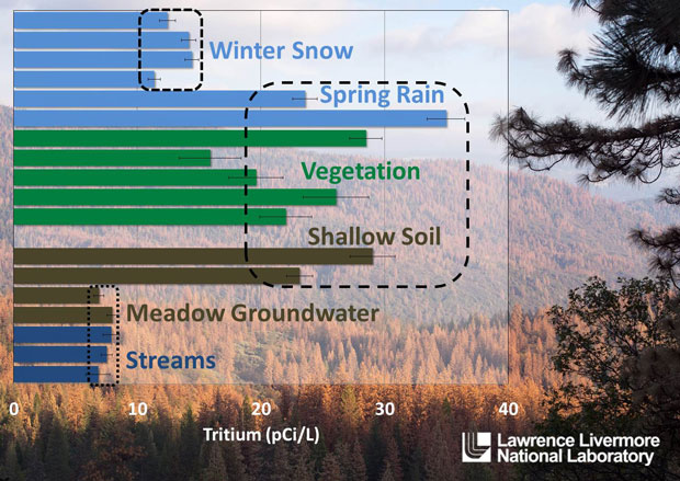
In FY16 we (1) procured a laser system at 2,656 nm for analyzing water vapor isotopologues, which are molecules that differ only in their isotopic composition; (2) completed testing of the laser system and fiber coupling to a gas cell in the laboratory; (3) completed sodium-22 collection procedures and calibrated gamma-counting efficiency; (4) demonstrated the capability on samples from streams and precipitation; (5) collected and analyzed monthly age tracer samples; (6) collected and analyzed stable isotope and tritium in soils and vegetation to distinguish plant water sources (see figure); and (7) collected input data for the ParFlow model.Publications and Presentations
- Visser, A., et al., Variability of residence time tracer concentrations at the Southern Sierra Critical Zone Observatory during the California drought. 2015 Fall Mtg., American Geophysical Union, San Francisco, CA, Dec. 14—18, 2015. LLNL-POST-679996.


